1.2 What is a GNSS?
People have probably always wanted (and needed) a simple way of determining exactly where on the earth they are, and in which direction they are travelling. Positioning and navigation are such basic problems for civilisation that they have commanded a lot of effort over the centuries.
Even today the ability to know where you are and where you are heading is crucial to many activities. As we saw in the previous section, over the years many technologies have tried to provide us with this information, but only GNSS has changed navigation and positioning so dramatically.
GNSS signals are freely available to everyone and are available 24 hours per day, seven days per week, anywhere on earth and in all weather. All that is required is some form of technology with a GNSS chip, called a receiver.
GNSS receivers use GNSS satellites as space-based reference stations to calculate positions on earth. Because the satellites are in high orbits, they avoid most of the problems encountered by many of the earlier land-based navigation systems. And because GPS and several other subsequent systems were primarily designed for defence, significant effort has been made (and is continuing) to ensure they are reliable, robust and not easily susceptible to interference.
The elements of GNSS
GNSS consists of three main segments:
- GNSS are worldwide navigation systems based on a constellation of satellites orbiting the earth. This is called the Space segment.
- The space segment works in conjunction with an Earth based network of ground stations, called the Control segment. It is also sometimes referred to as the Ground segment.
- The last segment is called the User segment and is made up of anyone with a GNSS receiver.
The space segment
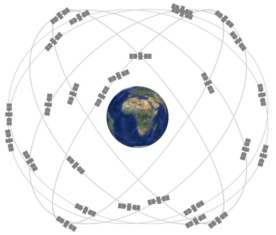
The space segment of a GNSS is made up of what is called a constellation of satellites. A constellation is a group of satellites that belong to a particular GNSS. They usually consist of a minimum of 24 operational satellites, often with spares in case one gets damaged or has operational issues.
Satellite is the shorthand name of the full Satellite Vehicles. This is often shortened to SVs.
Each satellite has several incredibly accurate atomic clocks, information about where it is meant to be at any given time, how ‘healthy’ it is, and information about where other satellites in its constellation are.
The information a satellite has about its own predicted orbit is referred to as an ephemeris, and it can best be thought of as a personal calendar.
The information that each satellite has about other satellites is called an almanac, and this is more like a shared or group calendar.
The GPS Navstar (Navigation Satellite Timing and Ranging) satellites have about a seven-year life span, so the constellation is constantly being replenished. These satellites are in orbits that are approximately 20 200 km above the earth and take about 12 hours to orbit the earth. From this we can see that the satellites travel at about 13 000 km/hr and are typically above the horizon for about 5 hours.
The GPS constellation is arranged into six orbital planes, each inclined at 55 degrees to the equator, and spaced evenly in longitude around the equator. This configuration is designed to ensure that users anywhere in the world have at least four satellites above the horizon at any time, day or night. See Figure 1.2(a) for an illustration of the arrangement.
The path that satellites take over the Earth is called their ground track.
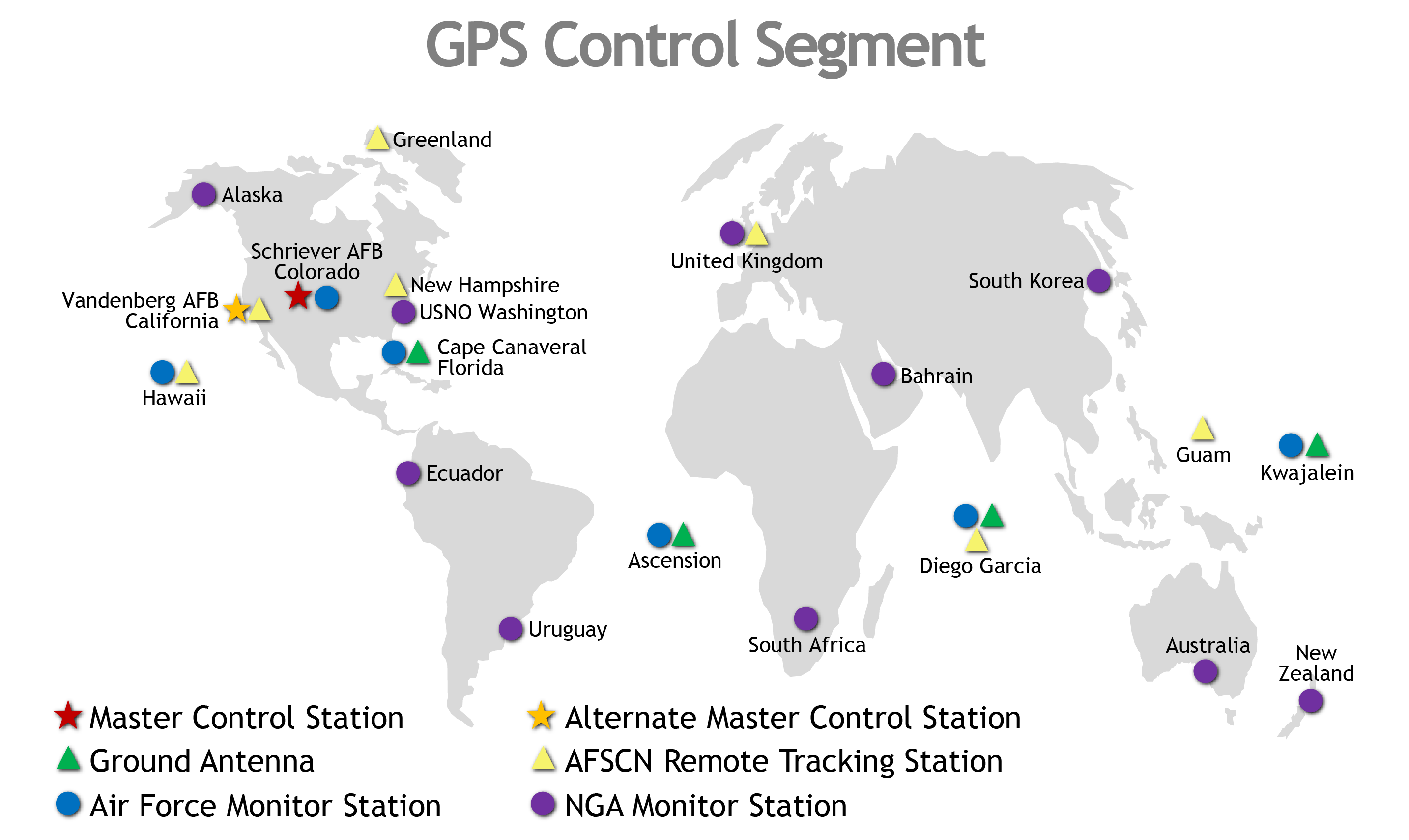
The control segment
The control segment is the segment that maintains the GNSS and contains ground control stations that communicate with the satellites.
The GPS control segment consists of five tracking stations, the positions of which are accurately known. The control segment comprises a master control station and four other monitor stations.
The master GPS control station is located at Schriever Air Force Base in Colorado Springs, USA. Figure 1.2(b) shows the location of the other monitor stations, spaced fairly equally around the earth and close to the equator. Six additional National Geospatial Intelligence Agency monitory stations were incorporated in 2005.
At the master control station the information is processed to yield clock corrections and the ephemeris of predicted orbits of each satellite. This information is then uploaded to the appropriate satellites, which in turn broadcasts the data to user receivers as the message part of the signal.
This predicted ephemeris is referred to as the broadcast ephemeris. Another form of ephemeris is produced by post-processing the data from the tracking stations and this is referred to as the precise ephemeris. Apart from the GPS control segment, several organisations also track GPS satellites and produce ephemeris data. We will discuss ephemeris information in more detail in a later section.
The user segment
The user segment comprises anyone who has a GNSS receiver!
This includes military and civilian users. Today GNSS chips are in every smartphone, and higher quality receivers are small enough and cheap enough to be carried by almost anyone.
The applications for GNSS are almost limitless and aren’t just in navigation. Banks use the accurate atomic clocks to deal with transfers of money across accounts and stock markets in Nano seconds.
Positioning and location applications for GNSS include surveying, navigation, machine guidance and control, agriculture, mapping, emergency services, vehicle tracking and recreational uses.
