1.1 Fundamentals
Learning Objectives
After successfully completing this chapter you should be able to:
- Describe how GPS improved on earlier navigation systems
- Identify some general uses of GNSS
- Explain the main segments of GNSS
- Explain the hierarchy of satellite systems
In the beginning…
Throughout human history, we have sought simple ways of determining where we are, and where we’re going on the Earth. Positioning, knowing where we are, and navigation, knowing where we’re going and how to get there, have always been some of the most basic problems facing civilisations.
Developments in science and technology have provided us with a multitude of solutions in the last few centuries, although none have been as revolutionary and globally adopted as the United States’ Global Positioning System (GPS). Utilising a combination of ground control and satellites to provide a location to a device capable of receiving a GPS signal, GPS set the stage for military and civilian use planet wide. No longer were we restricted by weather, daylight or location in being able to determine where we were!
The model used for GPS was quickly replicated by other countries and organisations, and now we have multiple systems providing us with positioning and navigation information. These are generically known as Global Navigation Satellite System or GNSS for short.
Understanding how these systems were developed, the fundamentals of how they work, the different applications and accuracies achievable using different methods of GNSS observation are important for any professional that provides positioning or navigation information as part of their work.
Almost everyone refers to all of the Global Navigation Satellite Systems collectively as “GPS”. We even do it in the name of this subject!
This is what is known as a Proprietary eponym or Generic trademark
– when the name for a successful product becomes the name that a class of objects is known by.
Radio waves
A Scottish physicist named James Clerk Maxwell developed a unified theory of electromagnetism in the 1870s, and in it he predicted the existence of radio waves. The following decade, a German physicist called Heinrich Hertz proved that Maxwell was correct, and communication was changed forever.
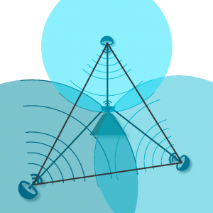
Radio waves also became useful in measuring distance. The concept was to measure the time it took for a radio signal to travel from a transmitter to a receiver. This signal travel time was then multiplied by the speed of light (about 300 000 000 metres per second) to obtain a distance between the transmitter and receiver.
If you knew where the transmitter was (and when it sent the signal) then you could position yourself on a circle with radius equal to the measured distance and centred on the transmitter.
This method is called trilateration and is shown in Figure 1.1(a).
LORAN
The LORAN (long range navigation) positioning system was developed and used during World War II, until the 1980s.
LORAN was based on triangulation from several radio transmitters on the coastline. Provided the user was within range of more than one transmitter, they could use the known position of the transmitters and the distance and angle between them to calculate position.
Unfortunately, this system was only available in some coastal areas and its accuracy varied, depending on electrical interference, atmospheric conditions, distance from transmitters and geographic variations. The LORAN system provided 2-dimensional (horizontal) positioning to an accuracy of about 300 metres.
Transit
Transit was a navigation and positioning system that was based on satellites. It was called the Transit System or ‘Sat-Nav’.
The satellite-based positioning was centred around the Doppler shift of the satellite signal. The signal changed as the satellite rose in the sky and then set. The effect was much like a car horn changing frequency as it moves towards, and then away from, a listener. The Transit system used this Doppler Effect (or change in frequency) to calculate position.
It was possible for surveyors on land to get a 3-dimension position accurate to less than a metre by post-processing about 2–3 days of data.
GPS
GPS provides an answer to one of mankind’s most troublesome questions: ‘Where on earth am I?’
Finally, at the beginning of the 1970s, the satellite age began in earnest when the United States Department of Defence gained Congress approval to develop a reliable and accurate global navigation system.
To overcome some of the limitations of previous systems, radio transmitters were placed in satellites that orbited the earth. The system was called the Global Positioning System (GPS), and it can provide 3-dimensional position fixes anywhere in the world. The system relies on using satellites as reference points.
Position accuracy can vary from tens of metres to a few millimetres depending on the measuring techniques, field procedures and quality of receivers used. We will discuss the different kinds of methods available to achieve different accuracies in the second part of this subject.
GPS not only provides an accurate and reliable position fix, it also provides very accurate time, and this has become critical to the banking sector.
GNSS
Once GPS became a globally useful technology, other countries and regions began investing in their own Global Satellite Navigation Systems. We will cover this in the next chapter.
