1.3 Global Systems
Since GPS became available for civilian use, there have been any number of navigation systems that have leveraged the same technology and approaches. From full global systems, to local ground based systems, there are over 20 systems currently in operation.
Global Primary Systems or GNSS are those that are full satellite constellations; that have global coverage. Regional systems are systems with only a few satellites that are designed to cover a specific area.
Satellite Based Augmentation Systems (SBAS) use the positioning information from GNSS combined with corrections sent via communication satellites to provide a commercial service to users. Global SBAS have global coverage, while Regional SBAS are restricted to specific areas.
Ground Based Augmentation Systems (GBAS) work in a similar way to SBAS, however, rather than using the communications satellites for corrections, they utilise a ground based method of relay, such as radio waves or mobile phones.
These are best explained by the hierarchy of satellite systems, as shown in Figure 1.3(a). We will discuss most of these systems in further detail throughout the book.
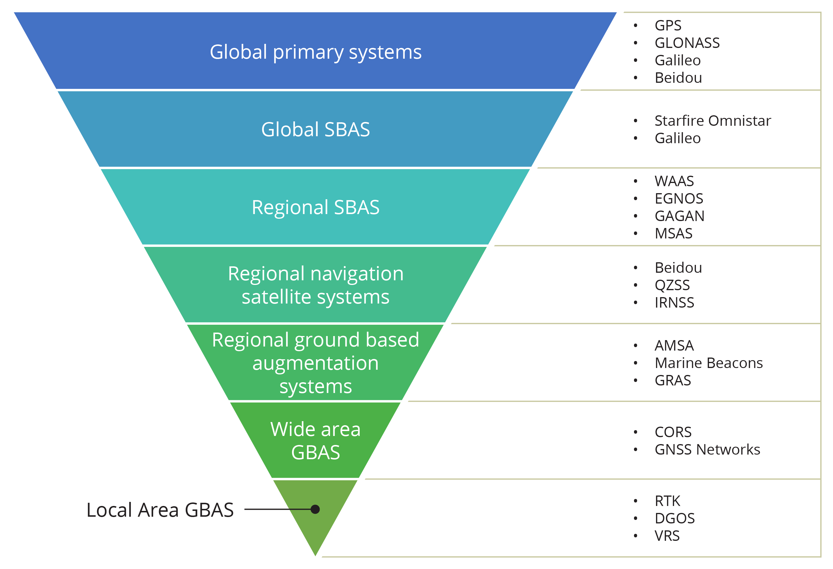
Global Primary Systems
There are currently four main global primary systems:
GPS
As previously discussed, GPS is run by the US Department of Defense, and was primarily developed for military purposes, however, since becoming available for civilian use has radically changed the navigation landscape.
GLONASS
The GLObal NAvigation Satellite System (GLONASS), deployed by the Russian Federation, is becoming an increasingly important system. The first GLONASS launch was in October 1982. Most satellites are launched three at a time on a Proton launch vehicle from Baikonur.
Overall, GLONASS is similar to GPS in terms of the satellite orbits and signal structure but there are some important differences. The GLONASS constellation uses three orbital planes rather than the six used by GPS.
While GPS satellites all broadcast the same radio frequency but different codes, GLONASS satellites all broadcast the same code but each satellite uses a slightly different frequency.
GLONASS also has two levels of service. Civil users have access to the Channel of Standard Accuracy which provides horizontal position accuracy of 60m (99.7% confidence) and vertical position accuracy of 75m (99.7 % confidence). Like the GPS, the GLONASS Channel of High Accuracy is only available to authorised users.
Galileo
Galileo is the European Union’s GNSS. The European Union identified that they had several issues in relying on GPS or GLONASS for positioning systems, including:
- sovereignty and security of Europe
- present system not fully meeting civil users’ performance requirements
- needing to ensure that users are not exposed to risks linked to a virtual monopoly
- capacity for European industry to compete on a fair basis in a fast growing market.
Identification of these issues led to the formal recommendation to the European Union to involve Europe in a new generation of Satellite Navigation Services, and Galileo was developed.
Galileo differed from the GPS and GLONASS systems in that it is a system under civil control.
The Galileo Constellation has three planes, circular orbits at a 56° inclination. The satellites orbit at a 23 616 km altitude.
Galileo also brought security to the EU in the wider sense, their technologically advanced and computer dependent society depends on GPS timing services for its services in energy, transport and financial transactions, and the cost of interruptions to the transport sector has been estimated at up to 300 million Euros per day.
Galileo Services
Galileo Services offer three levels of service:
Open Service
- provides position velocity and time services to mass market users
- similar to the future Standard Positioning System provided by modernised GPS
- accuracy better than 7 m worldwide and on an availability of 99%
- free of charge but, the quality of services is not guaranteed.
Commercial Service
- access commercially controlled
- provides improved service
- accuracy
- integrity
- ranging and timing service to knowledgeable professionals
- surveying
- meteorological forecasting
- time calibration.
Other Services
- The system is public regulated. There is no military involvement.
- Safety of life such as it is unencrypted; high integrity; confirmation of signal.
- The system provided near real-time; precise; and return link is feasible.
BeiDou
China has its own satellite navigation system that provides regional coverage of China and surrounds. This system is called BeiDou. It is named after the group of seven stars of the constellation Ursa Major, known in many cultures under different designations, in the UK ‘The Plough’, ‘Big Dipper’ in the US and ‘Big Mother Bear’ in Russia.
The first two BeiDou satellites were launched in 2000. Since 2001 China’s army and others have thus had access to a domestic satellite positioning system.
The third BeiDou satellite was blasted into orbit two and a half years later in 2003. Nearly four years later in 2007, the fourth BeiDou SV was put into orbit and operates as spare. The fifth BeiDou, launched in 2007, was not positioned in an approximately geostationary orbit 35 800 km above earth’s surface like the other four were. Instead, it is in an orbit of perigee 21 519 km and apogee 21 544 km.
The second generation of the BeiDou Satellite Navigation System (BDS), also known as COMPASS or BeiDou-2, will be a global satellite navigation system consisting of 35 satellites. The system was operational in China in December 2011, with 10 satellites in use.
BeiDou’s ground segment includes the central control station and orbit tracking stations at Jamushi, Kashi and Zhanjiang.
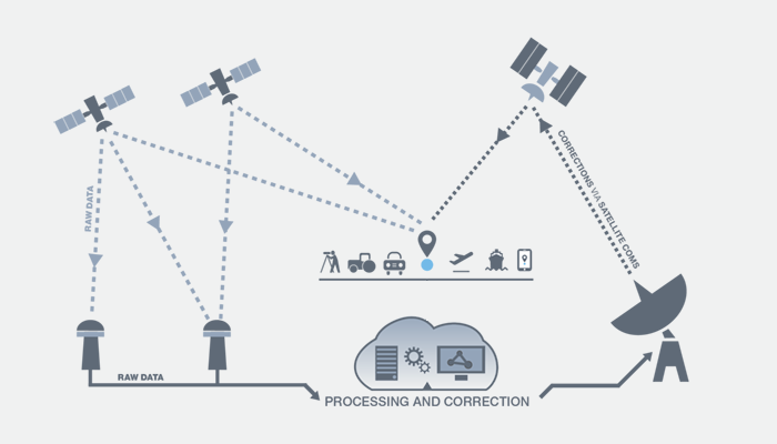
Global and Regional SBAS
Satellite Based Augmentation Systems utilise the positioning signal from GNSS and communication satellites to send signal corrections to users. The structure of a typical system is outlined in Figure 1.3(b).
Similarly to the GNSS set-up, SBAS systems have independent communication satellites and ground facilities. Users generally pay a subscription fee to access the corrected signal, which gives them a more accurate position.
Regional Satellite Systems
Several regions have launched their own satellites, that provide a ‘mini’ GNSS that focuses on their country or regional. The Japanese system QZSS is an example of a regional system.
QZSS
Quasi Zenith Satellite System (QZSS) has four satellites in different orbits, each at a 45° incline. Due to the high density of buildings in Japan, the satellites needed to orbit very high in the sky relative to the horizon. To allow for this, the satellites have a ground track of what is essentially a large figure of eight! A significant portion of this figure of eight tracks over Australia, and there are also three QZSS control stations in Australia.
GBAS
The main type of GBAS in use is also known as an Auxiliary system. They are designed to leverage the main GNSS or Regional Satellite System to provide improved local accuracy. They require a specialised receiver and are generally commercial services that require payment for access.
Table 1.3: GBAS Auxiliary Systems.
| Country | Main System | Aux System | Acronym |
|---|---|---|---|
| USA | GPS | Wide Area Augmentation System Local Area Augmentation System |
WAAS LAAS |
| Russia | GLONASS | Ground based Regional Augmentation System | GRAS |
| Europe | Galileo | European Geostationary Navigation Overlay Service | EGNOS |
| China | BEIDOU | Geosynchronous Earth Orbit Satellite System | GRIMS |
| Japan | QZSS | Multifunction Satellite Augmentation System | MSAS/MTSAS |
| India | GPS | GPS aided Geo augmented navigation Indian Regional Navigation Satellite System |
GAGAN IRNSS |
