2.2 Australian Datums
The current Australian datum is a geocentric datum called the Geocentric Datum of Australia 2020, or GDA2020 for short. Prior to GDA2020, we had GDA94 and before that AGD66 and AGD84.
Australian Geodetic Datum

Australia’s first official national geodetic datum was called the Australian Geodetic Datum (AGD). AGD was initially introduced in 1966, and was based on the local ellipsoid known as Australian National Spheroid or ANS. AGD had two versions: AGD66 and AGD84.
The fundamental characteristics of the AGD datum were:
- ellipsoid – the ellipsoid used was the Australian National Spheroid
- position – the position of this ellipsoid was determined to provide the best fit to the Australian regional geoid
- orientation – the National Mapping Council decided that the ANS should be parallel with the earth’s mean axis of rotation at the start of 1962, and that the meridian plane of zero longitude should be parallel to the zero meridian plane near Greenwich.
Note: the concept of longitude will be fully explained in the chapter on coordinate systems.
The passing of time revealed inaccuracies in the AGD66 coordinates, and this led to a new adjustment of the geodetic network in 1982. The basic definition of the datum was not changed for this purpose – the same ellipsoid was used (ANS) and the origin was held fixed. However, the addition of more observations and the use of improved error modelling and adjustment procedures gave rise to noticeably different coordinates. The resultant coordinate set was termed the AGD84. The comparison of the two datums is shown in Table 2.2(a).
Table 2.2(a): AGD66 compared to AGD84
| Designation | Australian Geodetic Datum (AGD) | |
| Datum | AGD66 | AGD84 |
| Geographic coordinate set | AGD66 | AGD84 |
| Grid coordinates | AMG66 | AMG84 |
| Reference Frame | N/A | |
| Epoch | 1966.0 | 1984.0 |
| Reference Ellipsoid | Australian National Spheroid | |
| Semi major axis (a) value | 6378160.0 | |
| Inverse Flattening | 298.25 | |
GDA94
A new and improved datum was adopted by Australia on 1st January 2000. This was known as the Geocentric Datum of Australia 1994 (GDA94).
GDA is a geodetic geocentric datum, based on a model of the whole earth, which has its centre coincident with the earth’s centre of mass. As the words imply, ‘geocentric datum’ is a datum that has its origin at the centre of mass of the earth.
The key advantage of the GDA over Australia’s earlier datum (AGD) is that GDA is totally compatible with satellite-based navigation systems such as GPS and with major international geographic systems.
GDA is the datum used in Australia, while GDA94 was the geodetic coordinate set (latitudes and longitudes) computed in terms of the datum at 1 January 1994. The reference frame for GDA94 was the International Terrestrial Reference Frame (ITRF1992), at epoch 1994.0.
The fundamental characteristics of the GDA datum, adopted by a meeting of the Intergovernmental Committee on Surveying and Mapping (ICSM) held in Canberra on 28–29 November 1994, are shown in Table 2.2(b).
The principal benefit of Australia adopting a geocentric datum was that it allowed people to use GNSS measurements, while also providing a single standard for collecting, storing and using geographic data. This ensures compatibility across various geographic systems at the local, regional, national and global level. For this reason the GDA forms the basis of the Australian Spatial Data Infrastructure (ASDI) – the infrastructure to manage Australia’s key spatial data sets.
Table 2.2(b): GDA94 parameters
| Designation | The Geocentric Datum of Australia (GDA) |
| Datum | GDA94 |
| Geographic coordinate set | GDA94 |
| Grid coordinates | MGA94 |
| Reference Frame | ITRF1992 (International Terrestrial Reference Frame 1992) |
| Epoch | 1994.0 |
| Reference Ellipsoid | GRS80 |
| Semi major axis (a) value | 6378137m |
| Inverse Flattening | 298.257222101 |
| Position | GRS80 is geocentric (centred on the earth’s centre of mass) |
| Orientation | The rotation axis is aligned with the direction of the Conventional International Origin (CIO) for the Polar motion and the zero meridian is as defined by the International Earth Rotation Service (IERS). |
The issues with GDA94 have arisen over time:
- Due to tectonic plate movement, Australia has been moving approximately 7cm per year, meaning the GDA94 positions have continued to move away from the ITRF92 positions. By 2020 the difference will be 1.8m.
- Improvements in global reference frames (ITRF2014 was created) have given a better definition of the shape of the Earth, and this has meant ellipsoidal heights have changed approximately 9cm.
- Parts of the Australian crust have changed.
To address these issues, GDA2020 was developed.
GDA2020
GDA2020 is the latest Australian Datum, and at the time of this module being written, is still being implemented in some Australian states and territories.
The main difference between GDA94 and GDA2020 is that GDA2020 has a future epoch – 2020.0. This means that Australia is moving towards the positions in GDA2020, rather than away from them like in GDA94.
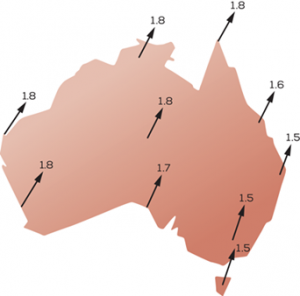
The shift from GDA94 to GDA2020 is approximately 1.8 m and is show in Figure 2.2(b).
The summary of the GDA2020 parameters are given in Table 2.2(c).
Table 2.2(c): GDA2020 parameters
| Designation | The Geocentric Datum of Australia (GDA) |
| Datum | GDA2020 |
| Geographic coordinate set | GDA2020 |
| Grid coordinates | MGA2020 |
| Reference Frame | ITRF2014 |
| Epoch | 2020.0 |
| Reference Ellipsoid | GRS80 |
| Semi major axis (a) value | 6378137m |
| Inverse Flattening | 298.257222101 |
| Position | GRS80 is geocentric |
| Orientation | The rotation (minor) axis is aligned with the direction of the Conventional International Origin (CIO) for the Polar motion and the zero meridian is as defined by the International Earth Rotation Service (IERS). |
Australian Height Datum
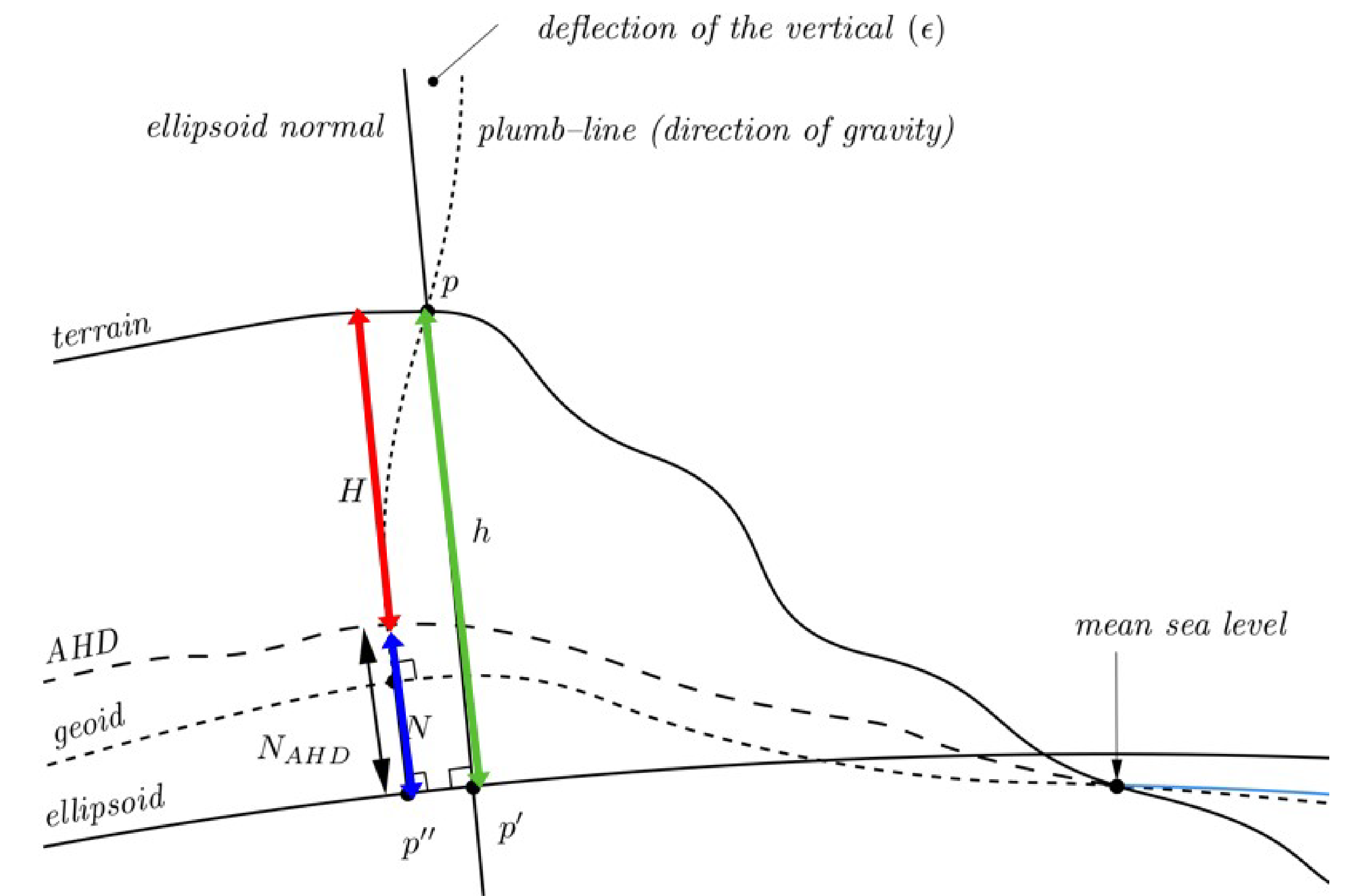
The geoid is a real surface, however, it is not a physical surface that we can directly observe. The level surfaces of the earth’s gravity field can be sensed, for example, by fluid in a vial (as in a spirit bubble).
On the other hand, surveyors have preferred a vertical datum that not only has physical reality, but is also universally recognised as a ‘sensible’ one, being prominent and obvious to non-surveyors. This surface is the mean level of the ocean.
In 1971 Geoscience Australia, the national agency responsible for datums (among other things), developed the Australian Height Datum 1971 (AHD71) for mainland Australia, and in 1979 developed AHD79 for Tasmania. AHD71 and AHD79 are both generally referred to as just AHD.
This was the first attempt to define a continent-wide height datum. Prior to this, Australia had many different levelling datums, all of them regional, and adopted by some government department or organisation to suit its own purpose. These local height datums were usually based on a local tide gauge as a zero level point.
AHD was tied to an estimate of Mean Sea Level (MSL), which was meant to approximate the geoid. The MSL estimate was calculated by having 30 tide gauges, distributed fairly uniformly around the Australian mainland coast, collect two years worth of data from 1966-1968. The 30 MSL estimates acted as the constraint for the calculations of heights, meaning they were given a set or fixed value of 0.0m. In surveying we generally abbreviate fixed value to just fixed – “This mark is fixed at 0.0m AHD”.
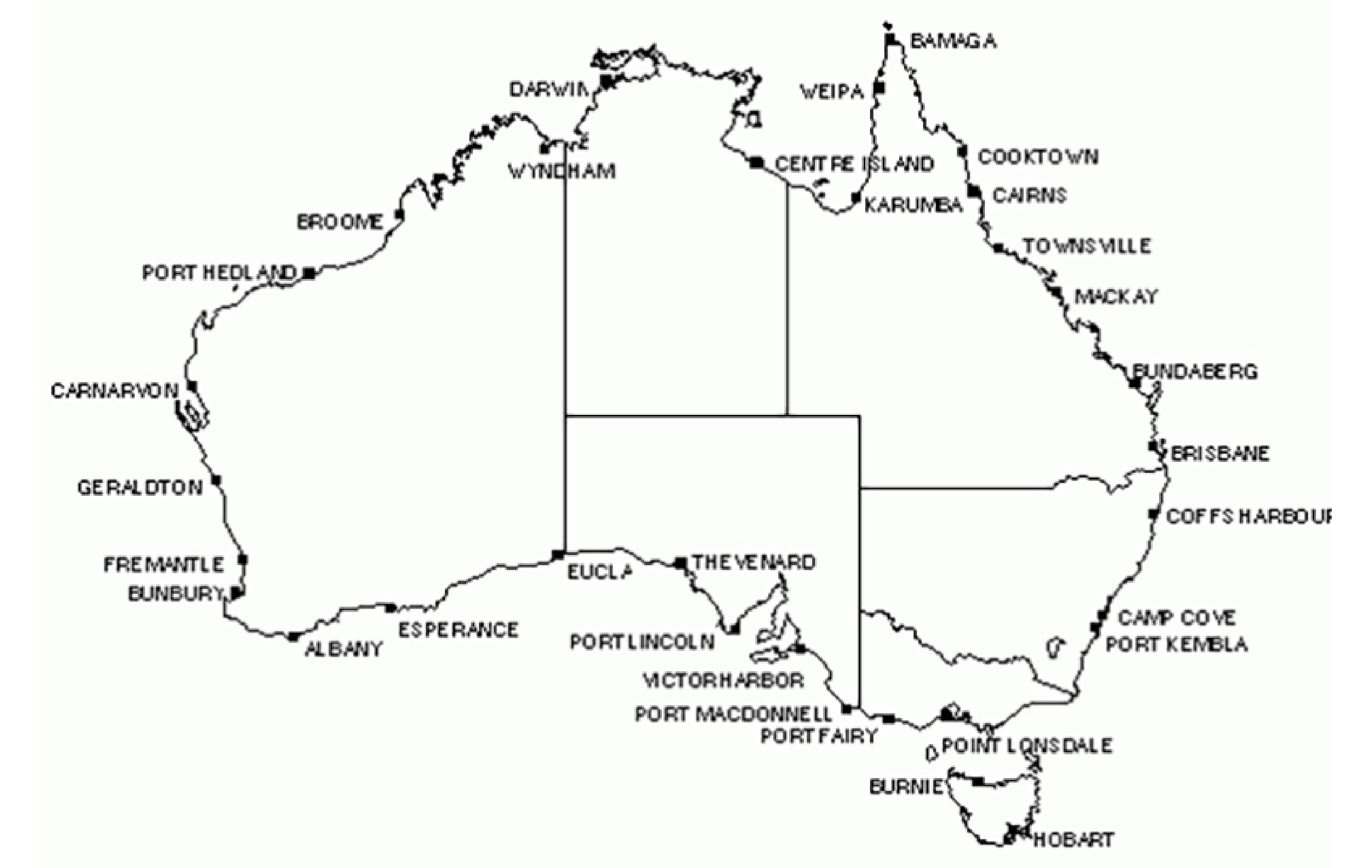
In Tasmania, the AHD is connected to MSL at two tide gauges, Burnie and Hobart. The AHD (Tasmania) is independent of AHD (mainland), with no connection ever being made between them. The tide gauges are shown in Figure 2.2(c).
Once MSL was determined, a number of benchmarks were installed near the tide gauges and the height transferred from the gauge to the marks by surveying levelling techniques.
From 1945-1971, surveyors had been completing a massive campaign of levelling all across Australia, called the Australian National Levelling Network. They completed 97 230 km of two way levelling. Two way meant that the surveyors would complete a loop, where they finished measuring on the same mark they started on. Each loop would ‘run’ through permanent benchmarks, hence lengths of levelling are often referred to as a run.
The data collected by the levelling runs were combined with the MSL data on the benchmarks, and it was all put through a statistical process that surveyors regularly use called least squares adjustment. The adjustment used the differences in heights determined by the levelling, and the known heights at the benchmarks, to assign an AHD height to all the marks in the network.
The location of the AHD tide gauges, and the levelling runs is shown in Figure 2.2(d). Also shown in this figure are the National Tidal Centre (formerly known as the National Tidal Facility) Australian Baseline Sea Level Monitoring Array (ABSLMA) locations. These locations are the more modern stations used to monitor MSL.
There have been a number of issues found with the initial AHD determination, including:
- The two year period for determining MSL is now considered to be inadequate.
- The temperature of the water in northern Australia compared to southern Australia was not considered, resulting in an almost 1m north-south tilt.
- Errors were found in the levelling runs.
Attempts to correct for these issues have, in part, been made by a geoid model correction product called AUSGeoid.
AUSGeoid
While not a datum in its own right, the geoid is a critical part of height datums, and is most often approximated by MSL for this purpose.
The geoid model currently used in Australia is called AUSGeoid and is essentially a grid of geoid ellipsoid separations, (values) in terms of the GRS80 ellipsoid and AHD, as shown in Figure 2.2(e). Newer AUSGeoid models also have considerations for known issues with AHD.
- AUSGeoid98 model provides ellipsoidal to gravimetric geoid values, but can have offsets with respect to AHD of up to 0.5m.
- AUSGeoid09 model provides ellipsoidal to AHD values.
- AUSGeoid2020 provides ellipsoidal to AHD values with uncertainty.
Geoscience Australia provides online tools to covert between ellipsoidal and AHD heights, based on a GDA94 or GDA2020 position.
New Zealand Datums
New Zealand uses the New Zealand Geodetic Datum (NZGD), NZGD2000. The parameters are shown in Table 2.2(d). The NZ datum is different from WGS84 and other ITRF datums, which are Earth centred and fixed, as it is a plate fixed datum, moving with the land mass as it moves and changes.
A plate fixed datum is used where a land mass is being subject to regular changes due to tectonic plate movement. The datum moves with the land mass, changing as the land does. This change is managed through a time dependent deformation model which models the deformation of the NZ land mass.
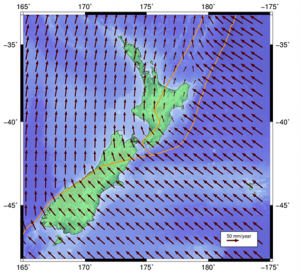
Being plate fixed means that the datum provides constant and unchanging positions, even though the land itself is moving. If you were to use positions in WGS84 for NZ, they would move as shown in Figure 2.2(e).
Table 2.2(d): NZGD2000 parameters.
| Designation | New Zealand Geodetic Datum 2000 |
| Datum | NZGD2000 |
| Reference Frame | ITRF96 |
| Epoch | 2000.0 |
| Reference Ellipsoid | GRS80 |
| Semi major axis (a) value | 6378137m |
| Inverse Flattening | 298.257222101 |
| Position | GRS80 is geocentric |
| Deformation model | LINZ deformation model |
